Late autumn is undoubtedly the best time to visit out of the way cemeteries here, when the days are still warm(ish), the critters have (mostly) taken to their winter beds, and poison ivy is easy to spot due to its bright red leaves.
Our trip this time was to the Holden Cemetery, located near the Pine Mountain community of Rabun County, Georgia, close to the North Carolina and South Carolina state lines. The cemetery isn’t difficult to get to, really, but it’s a long way out. It took over an hour to get there from Clayton, a trip of less than 20 miles.

I must admit that I hadn’t expected such a large cemetery out in the middle of nowhere, but the size isn’t surprising considering the cemetery’s age and location. Pine Mountain is a fairly isolated community, in spite of being at the midpoint of the three towns of Clayton, GA, Highlands, NC, and Mountain Rest, SC. In the late 19th century, Pine Mountain was a thriving community with a post office, a school, and several stores.1 Today, little remains of that community other than a few houses, some smaller family burial grounds, and a sign at the juncture of Warwoman Road and Hwy. 28. Community activities have moved slightly north to Satolah.

Only about half of the grave markers bore inscriptions. Because of the number of markers, I’ll only show a few of the more interesting features of the cemetery in this post. I will do my best to post the others in the future.
Perhaps the most intriguing items were the two walled in sections, located at the top of the knoll adjacent to one another.
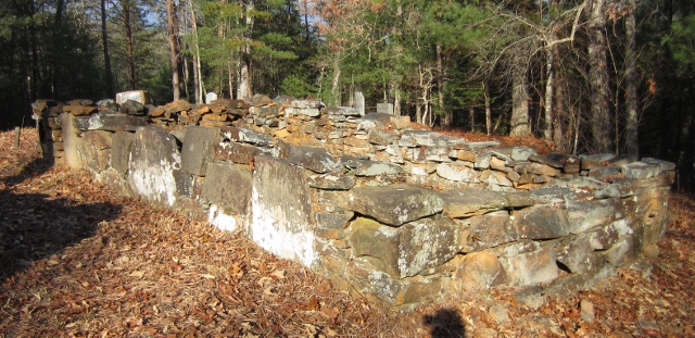
This is the walled-in section on the left, if viewed from the cemetery’s entrance. This picture was taken from the back looking toward the entrance. Notice the three large stones embedded into the wall. All three had very clear inscriptions.

H. H.
H. H.
DI 18 WR 1854

R. H.
DE FEB 7 D. 1859

F. H.
These three individuals were probably all members of the Holden family.
The other walled-in section had a similar stone embedded in the wall, but the inscription was too faded to make out.
There were many Holdens buried in this cemetery. The Bynums also had a fairly large section toward the back along the ridge behind the two walled-in sections.

The back of the cemetery behind the walled-in sections. The Bynum section is on the left and toward the rear in this photo.
The Bynum family member who most interested me was buried at the front of the cemetery, well away from the other Bynums.
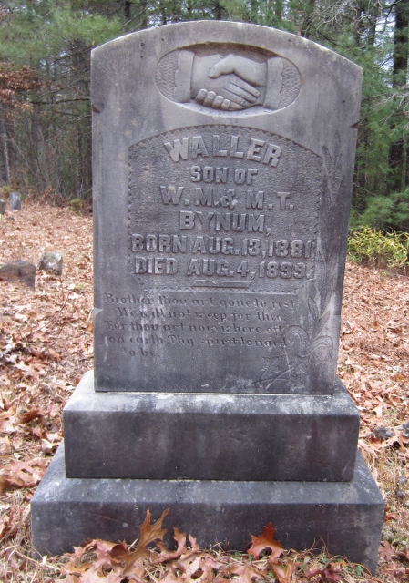
Waller
Son of
W. M. & M. T.
Bynum,
Born Aug. 13, 1881
Died Aug. 4, 1899
Brother thou art gone to rest
We will not weep for thee:
For thou art now where oft
on earth, Thy spirit longed
to be
Waller Bynum died an accidental and somewhat tragic death, an account of which was published in the local paper.2
The Sad Death of Waller Bynum.
On last Friday, about 4 o’clock, near Pine Mountain, Waller Bynum, aged 18 years, was killed while being dragged nearly two miles by a mule.
Young Bynum, divested of nearly every [piece] of clothing by the long distance he was dragged over rocks and the hard road, was found hanging by his left foot to an iron stirrup, dead. The young man was going to school to Miss Thornton, who has charge of the school at Mount Pleasant, about two miles from the home of the Bynum family. On the morning of the fatal accident he took two mules from home for the purpose of going to the Glade school house where his sister, Miss Genelia, has been teaching. After school he [started] for his sister riding one mule and leading the other and when about a mile from the Mt. Pleasant school in some way the saddle became turned on one of the mules—this is presumed from the fact at this point the print of his head was seen in the sand along the road for 30 or 40 years and then for some little distance no sign was seen. This shows that he was making an effort to regain his position on the mule, but the remaining distance showed that his body was constantly on the ground for nearly the distance of two miles. From all signs the mule was going with all the speed that was in his power. Not far from the place where he had had a scuffle with the mules his hat was found and along the entire distance blood and small pieces of his clothing were found in the road and the print of the body and blood along presents a sad scene.
His collar bone was broken and the skin and flesh was torn from the back of his head to the skull, and otherwise bruised and flesh torn.
The peculiar circumstance under which young Bynum lost his life make it a very sad one.
The interment took place at Long Bottom cemetery at 4 o’clock Saturday, in the presence of a grief stricken family and a sorrowing community.
The family have the sympathy of the entire county.
Lois Thornton, a teacher at the Mt. Pleasant school, wrote a memorial piece that was also published in The Tribune.3
One interesting tidbit taken from the account of Waller’s death is the name of the cemetery, which the author of that piece called Long Bottom cemetery.
Other families were buried in this cemetery, although not in the same number as the Holden and Bynum families. There were also markers for Fowlers, Littletons, Jollays, Binghams, Evans, and Rogers. A final stone I’d like to share is located near the Fowler burials, close to the back section of Bynums. It was laid flat in the ground, and the only inscription is the year 1859.

To get to the cemetery from Clayton, turn off of Hwy. 441 at the BP gas station onto Warwoman Road. Go about 11.4 miles. Turn right onto Willis Knob Road. Go about 5.9 miles. The road dead ends into a fork. Take the right fork and go about .9 miles. This road dead ends in the cemetery.
Warwoman Road is paved and usually navigable, although it may be icy in the winter months, especially January and February. Be watchful for fallen trees. Willis Knob Road is a gravel road that’s often used by locals as a horse riding trail. There’s also a horse camp out that way somewhere. The worst section of the road is the last mile to the cemetery, which is narrow and a little overgrown with low-hanging branches. A regular car should be able to navigate the road to this point, but after that I would recommend either walking in or bringing a tougher vehicle, such as a high-clearance, four-wheel drive. There’s no cell service that far out, so pack emergency supplies, including a good pair of walking shoes, food and water, and a couple of blankets, in case you get stuck.
When you’re driving out Willis Knob Road, keep an eye out for a sign that reads “Willis Knob to No 46.” Somewhere in this section is the foundation of the old Mount Carmel Church. The church’s cemetery is adjacent to the road on the right, not far from the sign, but no stones remain.
There is a homestead located (I believe) on the South Carolina side of the Chattooga River, just over the hill or so from the Holden Cemetery.4 We hiked out a few years ago and took pictures, which have mysteriously disappeared into the ether of one of our computers. That homestead supposedly belonged to the Holden family. From what I remember of it, all that remains is the chimney and foundation stones. If we hike out that way again, I’ll try to get pictures to share.
Have fun visiting the cemetery, and happy hunting.
* * * * *
1. Pine Mountain had a fairly regular correspondent to The Clayton Tribune in 1899. Other news was reported in the local papers as well.
2. The Clayton Tribune, Volume 2, Number 29, Thursday, August 10, 1899. As taken from page 175 of Rabun County, Georgia, Newspapers, 1894 – 1899.
3. The Clayton Tribune, Volume 2, Number 31, Thursday, August 24, 1899.
4. I wouldn’t in any way recommend trying to find the homestead from this cemetery. You’ll get lost and then I’ll feel responsible, so just don’t try it. To get to the homestead, continue out Warwoman Road until it dead ends at Hwy. 28. Go right toward South Carolina. The state line is marked by the Chattooga River. There are parking areas on both sides of the bridge on the left, if memory serves. The trail to the homestead is on the right, just past the bridge (again, if memory serves). From there, you have to know how to get to the homestead to actually get to the homestead, so I can’t recommend trying to find it without help. I’ll try to post better directions if we hike out that way again anytime soon.
